This post may contain affiliate links. As an Amazon Associate I earn from qualifying purchases.
* * *
I pride myself on knowing the best hikes in Virginia, but one snowy morning I was inspired by a mystery Pinterest photo. The only problem was I didn’t actually know where the trail was. Eventually, my Google search led me to the answer: the Great Channels of Virginia.
From that point on, I was even more excited. The Channels Natural Area Preserve lies just north of Abingdon, in a beautiful part of Virginia and not far from my favorite park in the state: Grayson Highlands State Park.
Read More: Abingdon (and Damascus) are home to the well-known Virginia Creeper bike trail. Find out why I like the half-day version better than the full-day ride.
Most Virginians Have Never Heard of The Channels
The sheer existence of The Channels stumps most locals. I had certainly never heard of them and I spend a lot of time reading outdoor articles about Virginia to make weekend plans. When I quizzed my friends, they had never heard of them either. Even some locals we ran into (who lived within an hour’s drive of the hike) were baffled when we mentioned our plans to them.
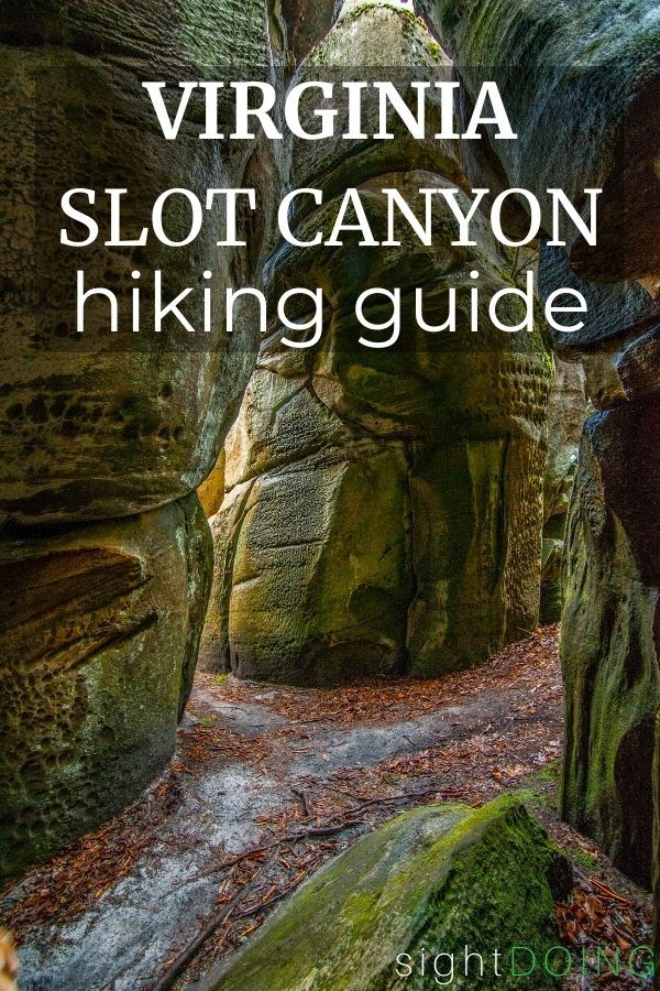
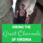
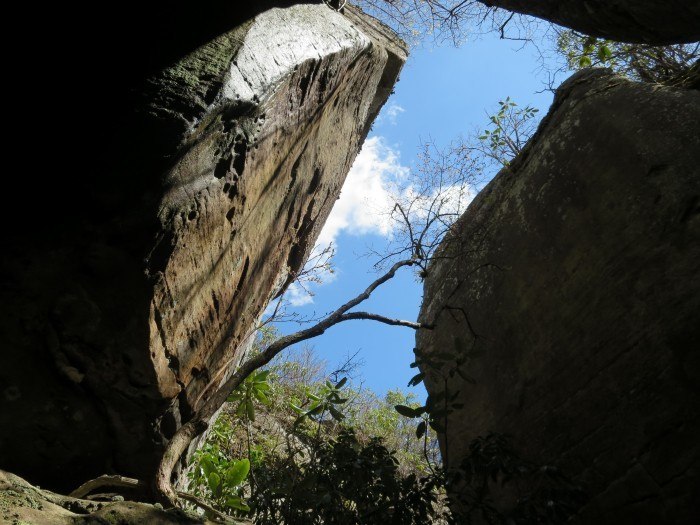
The Maze is One of a Kind (in Virginia)
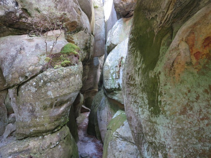
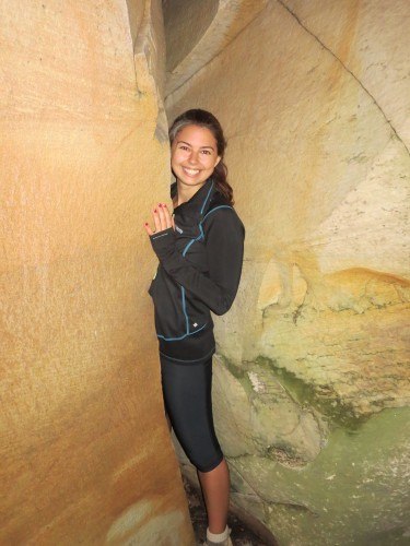
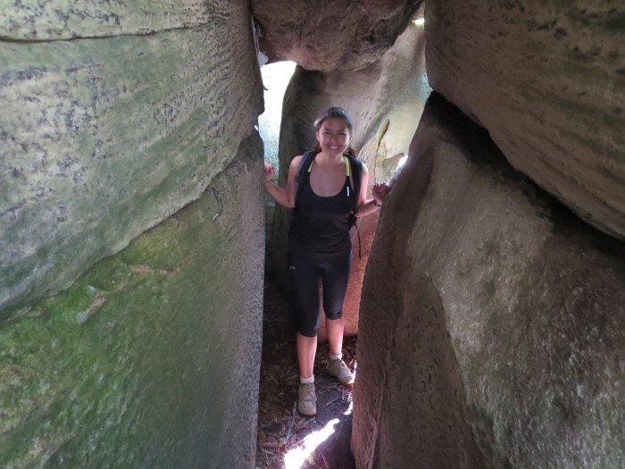
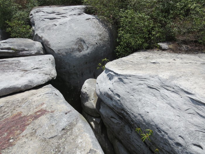
While slot canyons are somewhat common in the southwest USA, they’re pretty rare on the east coast. Sure enough, there’s nothing like the Channels anywhere else in Virginia. The labyrinth of crevices, passageways, and twists and turns means it’s easy to get lost. Enjoy exploring, but try to stay aware of the way back to where you started.
>>>> Want another one-of-a-kind adventure in Virginia?
Richmond is the only city with class IV rapids you can raft right through downtown!
The Channels VA Are 400 Million (yes, MILLION) Years Old
At one point, 400 million years ago, the Great Channels of Virginia were a sandstone cap rock. Geologists believe that the change into separate boulders, outcroppings, and crevices occurred during the last ice age. Permafrost and ice wedging led to freezing and expanding until joints were eventually shattered.
Anyone Can Hike the Channels
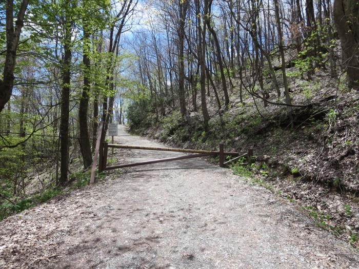
I’ve been on some monster hikes in Virginia, but this one is relatively accessible. The Brumley Mountain Trail — which leads to the Channels — is wide and well-marked. Although the trail gains about 1,000 feet in elevation, it’s gently sloped (for the most part) without complicated footing.
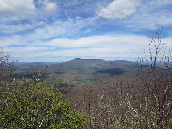
The trail is about three miles each way, so if you add in about an hour to explore the maze itself, you’ll want 3.5-5 hours round-trip. As a bonus, there are great views from Middle Knob along the way and some boulders that are lovely for sunbathing or napping on.
Heads up: Bears have been spotted in the area. The best way to avoid a bear encounter is just to let them know you’re coming. They’re scaredy-cats and want to avoid confrontation! Pack a bear bell or plan on making your own noise, like by singing along the trail.
If you see a bear, don’t get too close! Speak out loud in a calm voice, stay with your group to appear more intimidating, and back away slowly.
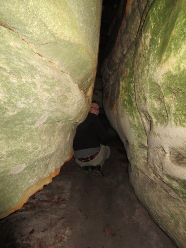
You Can Explore From Any Angle
The coolest part about the Channels is that you start out on top (watch your step — seriously) and then can head down to explore from below or even the inside out.
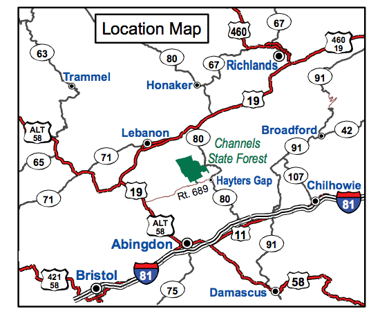
How to Get to The Channels Hiking Trail (VA)
Every website I went to gave me different directions on how to get there or a different set of coordinates for the trailhead. Let me clear up the confusion.
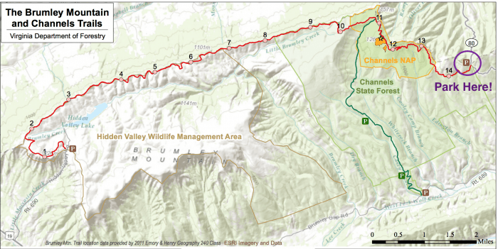
Assuming you want to do the 6-mile version of the hike, take I-81 to exit 24 (Meadowview). From there, continue on Route 80 West to the top of Clinch Mountain. You’ll drive past beautiful rolling hills and farmland, the small town of Hayter’s Gap, and head up a narrow, windy road. At the top, after about 14 miles of driving from the highway exit, there is a parking lot on the left hand side. There’s absolutely no way to miss it since there’s nothing else on the mountain until you hit that point. That’s it; piece of cake!
Where to Stay near The Great Channels of Virginia
There’s not much in the immediate vicinity, so you’ll need to plan this as a day hike. If you’re not camping, I recommend the Bolling Wilson Hotel in Wytheville, a cute nearby town. Look for their adorable breakfast baskets that are delivered to your door each morning so you can enjoy a continental breakfast in bed.
Otherwise, Abingdon is another great place to base yourself. Abingdon hotels are great for travelers who also want to bike the Creeper Trail, head to state parks, or just enjoy small town charm.
2020 Update: With so many people looking for outdoor things to do in Virginia, this trail has gotten more popular. The parking lot fills up, particularly on weekends. Get there early to ensure you find a spot.


Thank you for this simple review. I’m planning a trip with my kids for spring break and this sounds perfect. The directions you give – are they directly to The Channels or to the Brumley hike?
@Jennifer, The directions will take you to the parking lot at the start of the hike (3 miles each way). In the map, you’ll park near #14 and hike to the Channels between #11-12. The trail itself is easy to follow and well signed.
Thanks for your driving instructions. They were perfect. We had problems finding where to enter the rock formations though. I’m pretty disappointed. I don’t know if we did something wrong or if we weren’t tall enough to drop-down between the rocks. The kids still loved the trail but we may try to go back and do it over and see if we can find a better entry point.
We are going soon for our anniversary and are so excited! How do you actually enter the channels once you reach them?
@Babs, Just walk right in!
Hi Jennifer,
Thank you for sharing this.
I was wondering if you have ever heard of the Rock Maze at Rawley Springs, VA, just 15 minutes west of Harrisonburg around Hinton, VA? I found it on the net once and cannot find it now. I saw that some rock climbers use it and said that most people do not know about it. It is either on the boarder or inside the George Washington National Forest. Can you help me find it?
Thanks,
Laura
@Laura, I’ve never been, but I think you’re referring to Riven Rocks. Hopefully that will help you research more info!
Hi Becky,
Thank you for your quick response. I found The Maze I was looking for. Here is what the hikers that have been there replied back.
New comment on Why Virginia is for Lovers…
tylerandjanelle commented on Rock Hunt.
in response to Laura Legere:
What is the best way to get to the maze?
Hey Laura,
We used Lester Zook’s guidebook for rock climbing in Rockingham County. The section in there on Rawley Springs describes different sets of rocks as you hike back up the valley following the path along the stream. Eventually the path veers off right of the stream following the rock formations. About 45 minutes of hiking brought us up to the maze.
Alternatively, if you turn right, going over the bridge before you get to the national forest land, there is a development at the top of the mountain, the maze is behind the development, I really couldn’t tell you which direction. It is also considered trespassing so I wouldn’t recommend going that way.
Here is their photos.
https://tylerandjanelle.wordpress.com/2009/01/02/rock-hunt/
Thank you! I Just wanted to make sure as I’ve read a few other reviews with different hikes. This seems like the best with kids.
thanks for the info. a friend of my son, who I take on many hikes with us, just told me about the channels. we are from Maryland near Annapolis. he heard about it from friends while in Kentucky. I was looking for info on it when I found you.
@William, Hope you enjoy the hike!
Thank you. This was a great read! Can’t wait to hit the trail and see the channels for myself! 🙂
@Jeanette, Have fun hitting the trail!
I’m thinking this will be part of our family vacation this year. This, Fairystonepark, and then into Carolina for some gem mining/ hunting.
Do you have any tips on Fairystone State Park?
@Steve, When I went, Fairystone wasn’t too busy so it’s a good one to include! There were some materials there outlining how the rocks got their name and some walking paths. Have fun!
Thank you for this informative article. The photos are great, and your directions are very clear (and as you said, most other sights don’t have clear directions to the Channels.)
@MikeBSG, Happy to help and hope you enjoy the Channels!
This hike had been recommended on a number of occasions and your recommendation “sealed the deal” as we had visitors who hike with us. One is developing arthritis in her knees and hips so the 6 mile hike was a rather daunting idea. However, the hike is very close to 4 miles each way. We were told it was only a “quarter mile more” on more than one occasion and then found out, after walking what seemed like 1/4th mile, that we still had a mile left. Everyone descending the mountain said it was well worth the hike and they were right.
@Adrian, Glad you enjoyed the hike!
I really like your blog. Heading out on an epic road trip this weekend and will be biking the creeper trail as well as hiking The Channels. Thanks for your insight on both! One question–any places to take a quick dip along the creeper trail?
@Kim, Sounds like fun! The Creeper Trail runs near a creek and there are a few places to stop and wade/soak your feet but it’s not really deep enough to swim at all. There’s been a lot of rain this spring, so maybe it’s a little higher than normal but I’m guessing it’s still relatively shallow even with increased waterflow. Have a great weekend!
This is one my bucket list. Your blog is very helpful and I love the photos!
@Bill, happy to help and enjoy the hike!
I am planning to do the creeper trail one day and the channel the next day. I need to find a really nice campground near the Damascus area or in between Damascus and abingdon that has nice bathroom and shower facilities. Anyone have any suggestions? We are planning on doing this for Labor Day weekend.
@Marian, I also camp at Grayson Highlands State Park because I love it so much, but that’s a bit out of the way. There is camping right at Hayters Gap, but I haven’t personally stayed there: https://www.dgif.virginia.gov/vbwt/sites/hayters-gap-raven-ridge-campground/
Campground, no. But I can tell you that the Hiker’s Inn (475-3788) in downtown Damascus is very charming, cozy, and comfortable. It’s run by a former AT thru-Hiker and just a short walk from the Creeper Trail.
Campground, no. But I can tell you that the Hiker’s Inn (475-3788) in downtown Damascus is very charming, cozy, and comfortable. It’s run by a former AT thru-Hiker and just a short walk from the Creeper Trail.
We did this hike yesterday and wanted to share a tip – on the map of the trail above it looks like the channels are between 11 and 12, so that if you park in the parking lot closest to 14, it seems that if you reach “11” you’ve gone too far. We got to a tree marked 11 and thought we had missed the spur trail to the channels, so we doubled back. Luckily around 11.5 we passed some other hikers who told us that we had to keep going past the 11 marker to get to the spur trail. I hope this saves someone else some confusion and some extra walking. Once we found them (it isn’t hard if you keep going, the spur trail is clearly marked), they were well worth the hike. Our boys, ages 7 and 11, loved it and the hike was not too long or difficult for them. Thanks for the great driving directions; they got us right to the parking lot!
@Danielle, Thanks for sharing the extra information!
Hi Danielle,
That was my group. Glad you went back and enjoyed yourself.
Here are my photos from Sunday
https://matthewmperry.zenfolio.com/channels/slideshow
Matt
Matt,
You saved the day. At best we would have wasted more time looking for the spur trail, or at worst given up and gone home. Thank you so much!
Danielle
Very interested in what you’ve posted and love to hike however…. I am claustrophobic and some of the pics of the channels looks a little too tight for me. What do you think? Also, we usually hike with our yellow labrador – would you recommend the hike TO the channels only???
Thanks so much,
Pam
@Pam, When you get TO the channels, all of the mazes are completely optional and choose your own adventure. You don’t have to travel through any/all of them specifically, so just choose the one that makes sense for you and/or your dog.
What are the directions to drive to the shortest trail with access to the Channels? I won’t have much more than three hours to see them so I don’t want to take a very long trail and not reach the rocks :p
@Daniel, The directions above are for a 6-mile hike, which depending on your hiking speed could be as short as 2 hours (not including the time you spend wandering in the mazes).
Are there any good camping sites near The Channels?
@Mendy, My guess is yes but I haven’t personally camped in that area (most of my camping is backcountry on longer trails).
How do you get down to the “maze” area? I want to take my kids 5 and 7. I see above you said just walk right in. Is there an obvious entry point or some type of direction once you are on the top? Thanks!
@Latisha, The end of the trail ends at the maze area and it will be incredibly obvious once you’re there.
Thanks for this helpful information. The trail to the Channels is now well-marked with signs. According to my GPS, the distance to the spur trail to the Channels is 3 miles, then another .5 miles to the rocks. There is a sign at the spur trail. You can’t miss it. The 3 miles is definitely uphill and I wouldn’t call it an easy walk, but the effort is worth!
@Margo, Thanks for the update! I need to head back and appreciate the up-to-date info.
Heading to The Channels for the first time today! Glad we found this blog!
Are dogs allowed to hike the Great Channels trail?
@Leslie, Officially I don’t know, but usually LEASHED dogs are allowed on most Virginia trails unless explicitly stated otherwise.
Did you end up taking your dog to the channels? We are going in September and have a husky and wanted to figure out if it was a good idea or not.
Thanks in advance.
The channels are great. Once you reach the fire tower, the Channels are about 100 yards SW of the tower. Have been there twice and going back again next year after a family reunion. Well worth the time & effort.
Keep your eyes open for rattlesnakes and copperheads. That love the cool of rock crevices on a hot day. I recently found a den of half a dozen down in between rocks at another location.
@Dave, Thanks for the advice!
Thanks for all the great info. Planning ona spring trip with 7 of us who have hiked together for 20 years.
@Karen, That sounds like an awesome tradition!
We are going to the channels in a couple weeks and planning to do this hike. Do you think a husky would be okay to do the whole thing?
This was so helpful! I have been trying to find information about the slot canyon hikes so this was perfect. We recently bought a home in the area and are finishing up our projects. We had one last project to do which was a cabinet painting. We initially were going to do it ourselves but we decided to hire out help and go on a fun adventure instead. This was seriously the best hike, we love our new home state!